Mapping Historical New York: A Digital Atlas
with co-Principal Investigators Gergely Baics, Rebecca Kobrin, Laura Kurgan, and Mae Ngai, and project leaders Dan Miller and Wright Kennedy
a joint project between the Center for Spatial Research and Department of History at Columbia University (website launched October 2021)
Awarded Best Interactive/Digital Map and Best in Show (tie) in 2021 CaGIS Map Design Competition.
from Mapping Historical New York: A Digital Atlas project description:
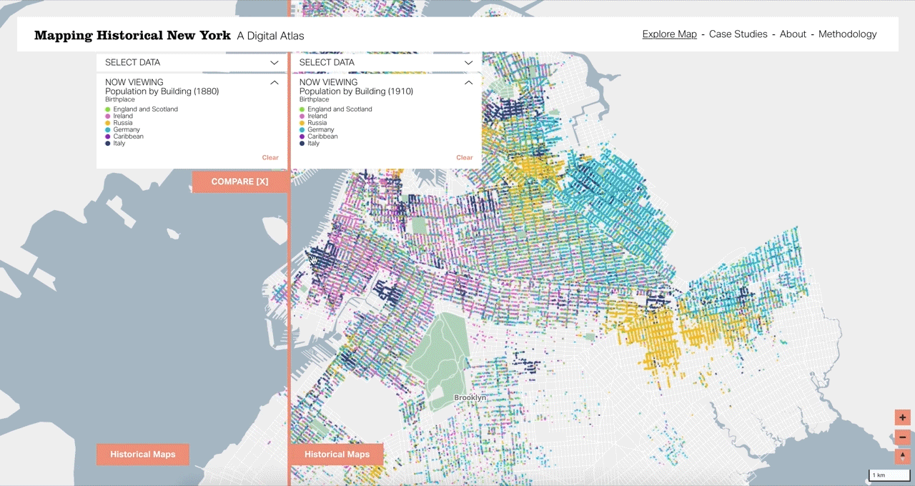
Mapping Historical New York: A Digital Atlas visualizes Manhattan’s and Brooklyn’s transformations during the late-nineteenth and early-twentieth centuries. Drawing on 1850, 1880, and 1910 census data, it shows how migration, residential, and occupational patterns shaped the city.
The Digital Atlas breaks new ground by locating each person counted in the Census at their home address, sometimes before the street grid was even established. To do this work we used preserved historical maps and city directories, and even traced census takers’ steps, to locate residences. The Atlas is a living project that will expand to include all five boroughs up to the 1940 census.
Related Links, Press, and Project Updates
MAY 2022: MHNY receives Best Interactive/Digital Map and Best in Show (tie) in 2021 CaGIS Map Design Competition.
DECEMBER 2021: “A Digital Map of Historical New York Offers an Extraordinary Level of Detail” on Columbia News.
NOVEMBER 2021: The MHNY team presented the project during a roundtable session at SSHA 2021.
OCTOBER 2021: Online Launch Event announcement and video, hosted by Columbia GSAPP.
OCTOBER 2021: “Mapping Historical New York: Reconstructing the City through Spatial Analysis” on Bwog: Columbia Student News.
JULY 2021: Gardiner Foundation press release, announcing project extension grant.